
Habitat mapping for Darwin region (including Bynoe Harbour)
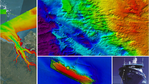
Image supplied by Northern Territory Government
This was a Northern Territory-run offset program in partnership with Geoscience Australia and Australian Institute of Marine Science which commenced in July 2014 and was completed in June 2018.
The scope of the offset program was to conduct seabed mapping to obtain high resolution bathymetric data; examine the abiotic patterns important to benthic communities; and characterise the seafloor fauna and flora (benthos) within Darwin and Bynoe harbours. These data improved knowledge and understanding of the marine habitats in Darwin and Bynoe harbours, which supports
evidence-based management decision-making for the protection and sustainable development of marine resources in these areas.
Project outcomes included:
- Improved knowledge and understanding of the distribution and characteristics of marine habitats in Darwin and Bynoe harbours.
- Improved evidence-based decision-making to support the sustainable development of Darwin and Bynoe harbours.
- Improved accessibility of marine data to the public through dedicated web services.
- Improved marine research capacity in the NT through partnerships between research agencies and government.
A full list of publications and data is provided below.
Habitat mapping for Darwin Harbour Region (including Bynoe Harbour) |
||
| Publication | Date | Link |
|
Outer Darwin Harbour Marine Survey 2015: GA0351/SOL6187 Post-survey report |
2015 |
|
|
Bynoe Harbour Marine Survey 2016: GA4452/SOL6432 Post-survey report |
2016 |
|
|
Outer Darwin Harbour Shallow Water Sediment Survey 2016: GA0356 - Post-survey report |
2016 |
|
|
Benthic sediment surveys of inner Darwin Harbour and shallow water areas in and around Bynoe Harbour (2017) GA0358 and GA0359 – Post-survey report |
2017 |
|
|
Final Report Seabed Characteristics |
2019/20 |
|
|
Final Report Characterising Abiotic Patterns |
2019/20 |
|
|
Final Report Characterising Seafloor Communities |
2019/20 |
|
|
Australian Government Geoscience Data and Publications |
2020 |
|